
The Brutal Truth About Santa Cruz de la Sierra
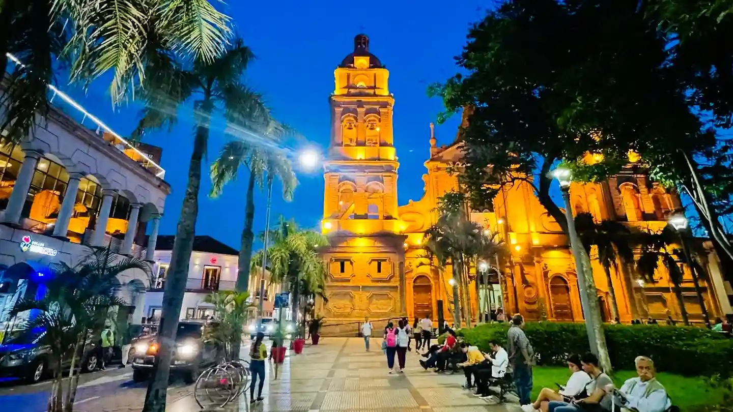
Table of Contents
- Quick Info Box
- The Reality of Arriving in Santa Cruz de la Sierra
- Historical & Cultural Significance of Eastern Bolivia
- Reality Check: What Instagram Hides About Santa Cruz
- Top Things to Do in Santa Cruz
- Photography, Lighting, and Drone Realities
- Exact Location, Navigation & The Ring System
- Weather, Climate & Surazo Warnings
- Essential Visitor Facilities in the City
- Estimated Budget Guide & Transport Costs
- What to Pack for the Bolivian Lowlands
- Safety & Responsible Tourism
- Nearby Attractions for Your Itinerary
- Where to Eat & Stay Nearby
- Frequently Asked Questions (FAQs)
Quick Info Box
- Exact Location: Andrés Ibáñez Province, Santa Cruz Department, eastern Bolivia.
- Local Name: Santa Cruz (Locals rarely say the full “de la Sierra”).
- GPS Coordinates: 17.7833° S, 63.1821° W.
- Altitude: 416 metres (1,365 feet) above sea level.
- Best Time to Visit: May to September (The dry winter season brings slightly cooler temperatures, avoiding the oppressive summer monsoon).
- Entry Fees: The city itself is free to explore, but specific parks, such as Biocentro Güembé, cost approximately 140 BOB (Bolivianos) for foreigners.
- Vibe/Highlight: A humid, chaotic economic powerhouse where tropical jungle meets heavy traffic and distinctly relaxed Camba lowland culture.
The Reality of Arriving in Santa Cruz de la Sierra
Stepping out of Viru Viru International Airport, the humidity hits you like a wet towel. If you are arriving from the freezing, oxygen-starved heights of La Paz or Cusco, the heavy, tropical air of Santa Cruz de la Sierra feels like a completely different continent.
You will immediately notice the noise. The city operates to the constant roar of 1980s Toyota Coaster buses, known locally as micros, tearing down the chaotic avenues. The smell of diesel exhaust frequently mixes with the sweet, heavy scent of tropical vegetation and street vendors frying empanadas de queso.
This is not a quaint Andean village frozen in time. It is Bolivia’s largest, wealthiest, and fastest-growing city. The pace is distinctly commercial, yet the people operate on a deeply relaxed, tropical timeline. You are in the heart of the Bolivian lowlands, and the atmosphere here is unapologetically loud, hot, and distinctly Camba.
Historical & Cultural Significance of Eastern Bolivia
Santa Cruz de la Sierra was founded in 1561 by the Spanish explorer Ñuflo de Chávez. Interestingly, the city was originally located 220 kilometres further east before being relocated due to indigenous attacks and harsh conditions. For centuries, it remained an isolated frontier town, completely cut off from the wealth and politics of the Andean mining centres like Potosí.
This historical isolation bred a unique culture. The people of eastern Bolivia, known as Cambas, are culturally and politically distinct from the Kollas of the Andean highlands. Their Spanish dialect is completely different, heavily influenced by indigenous Guaraní and Chiquitano languages, dropping the ‘s’ at the end of words.
The city only truly exploded in population during the 1950s when a paved highway finally connected it to Cochabamba. Today, understanding Santa Cruz, Bolivia, means understanding this fierce regional pride. The local government and business sectors often clash with the central government in La Paz, making this city the epicentre of Bolivian political opposition.
Reality Check: What Instagram Hides About Santa Cruz
Social media influencers love to post photos of themselves drinking coffee under the palm trees of the main square. What they do not show is the shirt-soaking sweat required to walk there in the middle of a January afternoon. The heat here is aggressive and inescapable during the summer months.
Furthermore, Santa Cruz de la Sierra is notoriously sprawling and car-centric. It is built on a massive system of concentric rings (anillos). Walking between neighbourhoods is often a miserable experience due to cracked pavements, aggressive stray dogs, and a total lack of shade.
You must also manage your expectations regarding nature. While the jungle surrounds the city, the immediate river (Río Piraí) is murky, muddy, and definitely not meant for swimming. If you want pristine Amazonian wilderness, you will need to book a flight further north; the city itself is an urban concrete jungle.
Top Things to Do in Santa Cruz
Sloth Spotting at Plaza 24 de Septiembre
This is the geographical and social heart of the city. You can buy a cheap cup of local coffee from a roaming vendor and sit on a bench facing the red-brick Basílica Menor de San Lorenzo. Look directly up into the massive tamarind and palm trees. There is a resident population of two-toed sloths living in the canopy, completely oblivious to the chaos below.
Eating at Las Cabañas del Río Piraí
Located at the end of Avenida Roca y Coronado, this is a dusty strip of thatched-roof restaurants backing onto the muddy Piraí River. It is entirely unapologetic and chaotic. You come here to sit on plastic chairs, fight off mosquitoes, and eat heavy local dishes like majadito (a salty rice and jerky dish) or baked zonzo (mashed yuca and cheese on a stick).
Escaping the Heat at Biocentro Güembé
This is a sprawling ecological park located just over the river in the Urubó district. It features massive walk-through butterfly domes, orchid gardens, and a series of giant, resort-style swimming pools. It feels heavily manicured and leans towards a resort vibe rather than raw nature. However, on a 35°C day, floating in these pools is highly necessary.
Getting Sandblasted at Lomas de Arena
About 17 kilometres south of the city centre lies a bizarre geological anomaly: massive, rolling dunes surrounded by tropical savanna. You must hire a 4×4 to get through the deep sand tracks to the entrance. You can rent a cheap sandboard and slide down the dunes, but be prepared for the intense winds that will leave you picking sand out of your ears for days.
Navigating Mercado Los Pozos
If you want to see the chaotic, beating heart of local commerce, walk through this massive, sprawling market. It is hot, claustrophobic, and overwhelming. You will find everything from raw meat hanging on hooks to pirated electronics and massive sacks of coca leaves. Watch your pockets carefully here, as pickpockets thrive in the tight, shoving crowds.
Photography, Lighting, and Drone Realities
Because of the flat topography of the Bolivian lowlands, the midday sun is intensely harsh and washes out all colour. If you want to photograph the colonial architecture around the main plaza, you must shoot between 6:30 AM and 8:00 AM. This is also when the streets are empty of traffic, and the temperature is bearable.
Drone flying is generally permitted around Santa Cruz, Bolivia, but you must use extreme caution. Do not fly near Viru Viru International Airport (located north of the 8th ring) or El Trompillo Airport (located squarely inside the city on the 2nd ring).
If you take a drone to Lomas de Arena, keep a low altitude. The sudden thermal updrafts and high-speed crosswinds off the dunes have crashed many tourist drones directly into the sand.
Exact Location, Navigation & The Ring System
Santa Cruz de la Sierra is structured like a massive dartboard. The historic centre is the bullseye, surrounded by a series of concentric circular avenues called anillos (rings). Avenues radiate outwards from the centre, cutting across the rings like spokes on a wheel.
For foreign backpackers, navigating the public micros is an intense but cheap experience. There are no official bus stops. You simply stand on the pavement, spot the route number painted on the bus windshield, and wave aggressively for it to stop. You pay the driver 2 BOB in exact change upon entering.
If you are a local or renting a car, driving here is a contact sport. Lane markings are treated as mere suggestions, and motorbikes frequently weave through blind spots. Parking inside the 1st ring during business hours is nearly impossible. Use official paid parking lots (parqueos) to avoid having your license plate confiscated by traffic police for illegal parking.
Weather, Climate & Surazo Warnings
The city features a tropical savanna climate. From October to March, the weather is brutally hot and wet. Temperatures frequently sit at 34°C with 80% humidity. When the tropical downpours hit during these months, the drainage systems fail immediately, and the outer ring roads turn into knee-deep rivers within twenty minutes.
However, the real weather anomaly you must prepare for is the surazo. During the winter months (May to August), freezing winds occasionally blow directly up from Patagonia and the Argentine pampas.
When a surazo hits, the temperature in eastern Bolivia can plummet from 30°C to 12°C in a matter of hours. Because local buildings have zero insulation and no central heating, 12°C feels bitterly cold. These cold fronts usually last between two and five days before the tropical heat returns.
Essential Visitor Facilities in the City
Unlike the remote Altiplano, Santa Cruz, Bolivia, is a highly developed modern city. You will not struggle for basic amenities here.
Mobile signal is excellent. Both Entel and Tigo networks offer strong 4G and 5G coverage everywhere inside the 8th ring. Every cafe, mall, and hostel will have reliable, fast Wi-Fi.
The city also boasts the best private healthcare infrastructure in the country. If you fall severely ill during your travel to Santa Cruz, clinics like Clínica Foianini offer international-standard care and have English-speaking doctors on staff. ATMs from Banco Mercantil and BNB are ubiquitous and reliably dispense both Bolivianos and US Dollars.
Estimated Budget Guide & Transport Costs
Prices in Santa Cruz de la Sierra are slightly higher than in Sucre or La Paz, reflecting its status as an economic hub.
Disclaimer: The Bolivian Boliviano (BOB) exchange rate fluctuates. Use this table as a baseline estimate for 2026.
| Item/Service | Cost for Locals (BOB) | Cost for Foreigners (BOB) | Practical Notes |
| Micro Bus Ride (City) | 2 BOB | 2 BOB | Hand the driver exact change. No one has change for a 50. |
| Uber / InDrive (1st to 4th Ring) | 15 – 20 BOB | 15 – 25 BOB | InDrive is cheaper but requires you to negotiate the price in the app. |
| Biocentro Güembé Entry | 70 BOB | 140 BOB | Massive price markup for non-residents. Bring your own towel for the pools. |
| Street Empanada / Cuñapé | 5 BOB | 5 BOB | Buy these early in the morning when they are fresh from the oven. |
| Taxi from Viru Viru Airport | 60 – 70 BOB | 70 – 90 BOB | Negotiate the price before getting in. The drive takes 30-45 minutes. |
What to Pack for the Bolivian Lowlands
Forget the thick alpaca jumpers you bought in Cusco. You are packing for the deep tropics now.
- Breathable Cotton or Linen Clothing: Avoid synthetic fabrics. You need clothes that dry quickly when soaked in sweat.
- Strong DEET Insect Repellent: Dengue fever is a very real, common threat during the wet season. You must spray your ankles daily.
- Light Waterproof Jacket: Essential for sudden monsoon downpours and blocking the bitter wind during a surazo.
- Sturdy Sandals: Pavements are often cracked and flooded. Waterproof walking sandals are infinitely better than soggy trainers.
- Travel Umbrella: Provides critical, portable shade from the intense midday sun when walking between avenues.
Safety & Responsible Tourism
- Avoid the Outer Rings at Night: The city is generally safe during the day inside the 4th ring. However, wandering around the outer rings (like Plan 3000 or Villa 1ero de Mayo) after dark is asking to be mugged.
- Micro Bus Pickpockets: Keep your backpack on your chest when riding crowded public transport. Thieves operate with razor blades to slice bags open.
- Respect the Sloths: If you see a sloth in the main plaza or in a park, do not touch it or try to feed it.
- Carry Your Passport Copy: The FELCC (local police) occasionally run random ID checks. Always carry a laminated colour copy of your passport photo page and entry stamp.
Nearby Attractions for Your Itinerary
If you want to escape the concrete and traffic of Santa Cruz de la Sierra, you need to head out into the surrounding province.
Cotoca (Drive time: 40 minutes east)
A small, deeply traditional town famous for its pottery and sugarcane byproducts. The main plaza is surrounded by vendors selling jalea (a thick, dark sugarcane syrup). It is a vital pilgrimage site for locals, especially during the December festival for the Virgin of Cotoca. Take a shared trufi (taxi) from the city centre for a few Bolivianos.
Espejillos (Drive time: 1.5 hours west)
A series of natural, clear-water pools and waterfalls carved into the jungle rock. It is the perfect antidote to the city heat. The final 30 minutes of the drive require navigating a rough dirt road and crossing a shallow river, so you must hire a 4×4 or a dedicated taxi to get there.
Porongo (Drive time: 45 minutes west)
Located across the Piraí River, this is a quiet, colonial-style town with dirt streets and a beautiful 18th-century church. It feels like stepping back in time compared to the hyper-modern Ventura Mall just across the bridge. It is incredibly busy on Sundays when city locals drive over to eat traditional pork dishes.
Where to Eat & Stay Nearby
El Aljibe Comida Típica:
If you want to taste authentic lowland food, come here. Set in a restored traditional house with a central courtyard, they serve the best majadito (rice, plantains, egg, and jerky) and sopa de maní (peanut soup) in the city. The portions are aggressively large.
Marriott Santa Cruz de la Sierra Hotel:
Located in the upscale Urubó neighbourhood on the 4th ring. If you have the budget, this offers powerful air conditioning, a massive pool, and a stark contrast to the gritty backpacker hostels in the centre.
Jodina Hostel:
Located right near the main plaza. This is the classic hub for foreign backpackers traversing eastern Bolivia. It has a pool, decent Wi-Fi, and staff who can help you figure out which chaotic bus terminal you need for your onward journey.
Frequently Asked Questions (FAQs)
Is there altitude sickness in Santa Cruz?
No. The city sits at just 416 metres above sea level. If you have just arrived from La Paz (3,600 metres), you will actually feel superhuman here due to the abundance of thick, oxygen-rich air.
Can you drink the tap water in Santa Cruz?
Absolutely not. While the city’s water treatment is better than in rural areas, the pipes are old, and contamination is common. Strictly stick to bottled water for drinking and brushing your teeth to avoid severe stomach issues.
Is Uber available and safe to use?
Yes. Uber operates here, alongside a much more popular local app called InDrive. Both are significantly safer and more reliable than hailing random street taxis at night, as the route is tracked and the driver’s identity is verified.
How many days do you actually need in the city?
For most tourists, two full days are enough to see the central plaza, eat local food at the river, and visit a nearby park like Güembé or the dunes. It is largely a transit hub rather than a long-term tourist destination.
Why are there no indigenous women in bowler hats here?
The traditional Andean dress (polleras and bowler hats) belongs to the Kolla culture of the high-altitude mountains. Santa Cruz, Bolivia, is dominated by Camba culture, where the traditional dress is light cotton, and the modern daily wear is mostly shorts and t-shirts due to the tropical heat.
Embrace the sweat, eat the cheese bread, and enjoy the chaotic, vibrant energy of Bolivia’s tropical engine room.