
The Brutal Truth About Visiting Lake Titicaca
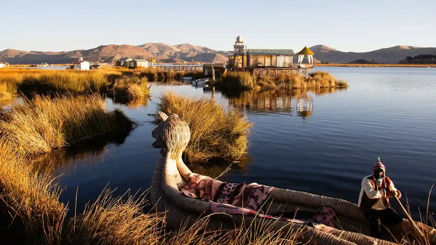
Table of Contents
- Quick Info Box
- The Reality of Arriving at Lake Titicaca
- Historical & Cultural Significance of the Waters
- Reality Check: What Instagram Hides About Puno
- Top Things to Do Around Lake Titicaca
- Photography, Lighting, and Drone Realities
- Exact Location, Navigation & Border Crossings
- Weather, Climate & High-Altitude Warnings
- Essential Visitor Facilities on the Islands
- Estimated Budget Guide & Transport Costs
- What to Pack for the Altiplano
- Safety & Responsible Tourism
- Nearby Attractions for Your Itinerary
- Where to Eat & Stay Nearby
- Frequently Asked Questions (FAQs)
Quick Info Box
- Exact Location: Border of southeastern Peru (Puno region) and western Bolivia (La Paz department).
- Local Name: Titiqaqa (in both Quechua and Aymara languages).
- GPS Coordinates: 15.8402° S, 69.4071° W.
- Altitude: 3,812 metres (12,507 feet) above sea level.
- Best Time to Visit: May to September (The dry winter season brings clear skies, though nights are freezing).
- Entry Fees: Vary wildly by island. A standard local ferry to Taquile costs around 30 PEN (Peruvian Sol), while landing fees on smaller islands range from 5 to 10 PEN.
- Vibe/Highlight: A harsh, high-altitude inland sea where gritty port towns meet intensely traditional Andean culture and ancient mythology.
The Reality of Arriving at Lake Titicaca
Stepping off a bus in Puno, Peru, the first thing that hits you is the sheer lack of oxygen. At over 3,800 metres, the air is aggressively thin. Walking a single block with a backpack feels like you have just run a sprint.
The light here is different, too. Because the atmosphere is so thin, the sun does not just shine; it radiates with a harsh, unblinking glare that instantly burns unprotected skin. The lake itself is overwhelmingly massive. It looks more like an ocean, stretching out into a deep, heavy, sapphire-blue horizon that eventually blurs into the Bolivian Andes.
You will immediately smell the distinct scent of the port: a mix of diesel exhaust from the ferries, frying trout from the street stalls, and the damp, earthy scent of rotting totora reeds. It is not a polished resort destination. It is a working, breathing, and often struggling high-altitude environment.
Historical & Cultural Significance of the Waters
Lake Titicaca is not just a body of water; it is the mythological womb of the Andes. According to enduring Inca mythology, the creator god Viracocha rose from these freezing waters to create the sun, the moon, and the first humans.
Long before the Inca expanded their empire here, this region was dominated by the Tiwanaku civilisation, which thrived on the Bolivian side between 500 and 1000 CE. The lake served as a crucial agricultural and spiritual centre. Recent underwater archaeological expeditions have actually uncovered the submerged ruins of ancient temples and agricultural terraces off the coast of the islands.
Today, the lake remains fiercely divided between the Quechua and Aymara indigenous groups. Their survival strategies, like building islands out of reeds or farming on steep, rocky terraces, are direct continuations of techniques developed over a millennium ago. The history here is not confined to museums; it is actively lived by the people navigating the lake every day.
Reality Check: What Instagram Hides About Puno
Social media loves to show perfectly framed, serene photos of women in colourful skirts standing on pristine reed islands. The reality of the Lake Titicaca tours is often much more transactional and exhausting.
Firstly, the gateway city of Puno, Peru, is objectively unattractive. It is a sprawling, chaotic, and unfinished brick city that crawls up the surrounding hills. It is dusty, traffic-clogged, and bitterly cold at night. There is no romantic waterfront promenade here.
Then there is the elephant in the room: the Uros floating islands. While historically fascinating, the islands closest to Puno have devolved into a highly orchestrated tourist trap. As soon as you step off the boat, you are given a rehearsed presentation, followed by aggressive pressure to buy expensive, mass-produced souvenirs. If you go expecting an untouched, authentic interaction, you will leave deeply disappointed.
Top Things to Do Around Lake Titicaca
Walking on the Uros Floating Islands
Despite the commercialisation, walking on an island made entirely of woven reeds is a strange, necessary experience. The ground feels spongy and unstable beneath your boots. The locals constantly add fresh green totora reeds to the top layers because the bottom layers are continually rotting away in the lake. If you want a more authentic experience, hire a private boat to take you to the floating islands furthest from Puno, where the commercial pressure drops significantly.
Hiking Taquile Island for Textile Culture
Taquile Island is entirely different from Uros. It is a solid, rocky island famous for its strict societal rules and incredible textile art. Here, the men do the knitting. You will see men walking the steep stone paths, constantly knitting intricate hats (chullos). The hike from the dock to the main plaza is brutally steep. At 3,900 metres, this hike will test your lungs, but the panoramic views of the high altitude lake from the main square are unmatched.
Experiencing a Homestay on Amantani Island
If you want to escape the day-tripper crowds, take a three-hour boat ride to Amantani. There are no hotels here, only rustic homestays with local families. You will eat quinoa soup in a dirt-floor kitchen and communicate through hand gestures if you do not speak Spanish or Quechua. In the late afternoon, hike up to the twin peaks of Pachamama (Mother Earth) and Pachatata (Father Earth) to watch the sunset turn the lake into liquid gold.
Exploring Copacabana and the Bolivian Side
Crossing the border brings you to Copacabana, Bolivia. It is a slightly more relaxed, backpacker-friendly town compared to Puno. The main draw here is the massive, gleaming white Basilica of Our Lady of Copacabana. Locals bring their vehicles here, covered in flowers and ribbons, to be blessed by the priests with holy water and beer. It is a fascinating collision of Catholic and indigenous beliefs.
Walking the Ancient Paths of Isla del Sol
From Copacabana, take a boat to Isla del Sol (Island of the Sun). According to legend, this is exactly where the sun was born. There are no paved roads and no cars on the island. You will spend your day walking ancient Inca trails, passing grazing llamas, and exploring the Pilko Kaina ruins. The sheer drop-offs and the deep blue water below make it the most visually stunning spot on the entire lake.
Photography, Lighting, and Drone Realities
The Lake Titicaca weather dictates your photography. The high-altitude sun washes out colours by midday, creating harsh, ugly shadows. You must shoot during the golden hour (6:00 AM to 7:30 AM, or 4:30 PM to 5:30 PM). A circular polarising filter is mandatory to cut through the intense glare coming off the water.
When photographing local Aymara or Quechua people, always ask first. Many older locals deeply dislike having a camera shoved in their faces and will demand money if you take a sneaky shot.
Regarding drones: There is no blanket ban over the lake, but you cannot fly them near the naval bases in Puno. Do not fly drones over the Uros floating islands without explicit permission from the island president; the loud buzzing agitates the locals and disrupts their daily work.
Exact Location, Navigation & Border Crossings
Lake Titicaca straddles the border. If you are starting in Peru, you will likely arrive in Puno. Cruz del Sur operates highly reliable, comfortable overnight buses from Cusco (7 hours) and Arequipa (6 hours). If you have a massive budget, the PeruRail Titicaca train from Cusco to Puno is a slow, luxurious, ten-hour scenic journey.
For independent travellers crossing from Peru to Bolivia, take a local colectivo (shared minibus) from the Puno terminal to the Kasani border crossing. You will walk across a literal line on the road. Get stamped out of Peru at the small office, walk 100 metres, and get stamped into Bolivia. From the Bolivian side, Copacabana, Bolivia, is just a 15-minute shared taxi ride away.
(Note for foreigners: Ensure you check Bolivian visa requirements. US citizens, for example, must pay a hefty visa fee in pristine US dollar bills at this border.)
Weather, Climate & High-Altitude Warnings
The climate is unforgiving. During the dry season (May to October), daytime temperatures hit a pleasant 15°C to 18°C. However, the moment the sun dips below the horizon, the temperature plummets to freezing. You will need a t-shirt at noon and a heavy down jacket by 6:00 PM.
The rainy season runs from December to March. The lake region receives heavy, freezing downpours that turn the dirt roads of Puno and Copacabana into muddy rivers. Boat crossings become incredibly rough and nauseating during these months.
The biggest threat is altitude sickness (soroche). Do not fly directly from sea level to Juliaca (the nearest airport to Puno) and expect to function. You must acclimatise in lower-altitude cities like Arequipa or Cusco for a few days first. Symptoms include splitting headaches, severe nausea, and insomnia.
Essential Visitor Facilities on the Islands
Facilities range from basic to nonexistent once you leave the mainland. In Puno and Copacabana, you have access to ATMs, pharmacies, and decent Wi-Fi.
On the islands (Taquile Island, Amantani, Isla del Sol), expect primitive conditions. Mobile signals drop out constantly, particularly inside the stone houses. There are no ATMs on the islands; you must bring all the small-denomination cash you need.
Toilets on the islands are usually manual-flush squat toilets. You must bring your own toilet paper and hand sanitiser. Running water is scarce and strictly for agricultural or cooking use, not for long, hot showers.
Estimated Budget Guide & Transport Costs
Use this as a practical baseline. The main tourist hub is in Peru, so prices are listed primarily in Peruvian Soles (PEN).
Disclaimer: Peruvian Sol (PEN) and Bolivian Boliviano (BOB) exchange rates fluctuate. These are baseline estimates for 2026. Use local currency; foreign coins are useless here.
| Item/Service | Cost for Locals (PEN) | Cost for Foreigners (PEN) | Practical Notes |
| Public Ferry to Taquile (Return) | 20 PEN | 30 – 35 PEN | Buy directly at the Puno port. Avoid buying through hotel middlemen. |
| Uros Islands Entry Fee | 5 PEN | 8 PEN | Collected by a local official in a small boat before you land. |
| Amantani Homestay (1 Night) | 40 PEN | 50 – 60 PEN | Usually includes a basic dinner and breakfast. Pay the family directly. |
| Bus: Puno to Copacabana | 25 PEN | 30 – 40 PEN | Roughly a 3-4 hour journey, including the time spent at the Kasani border. |
| Public Toilet on Islands | 1 PEN | 2 PEN | Have exact change. No one will break a 50 Sol note for the toilet. |
What to Pack for the Altiplano
Because of the massive temperature swings and harsh environment, packing correctly is crucial.
- High-SPF Sunscreen (SPF 50+): The atmosphere blocks very little UV radiation at this altitude. You will burn quickly.
- Layers: A breathable base layer, a fleece mid-layer, and a windproof outer jacket. You will take them on and off all day.
- Diamox (Acetazolamide): Prescription medication to help prevent severe altitude sickness.
- Coca Leaves or Candies: Sold everywhere in Puno. Chewing them is the local, traditional remedy for the altitude.
- Small Denomination Cash: Bring 10, 20, and 50 PEN notes. Islanders cannot make change for large bills.
- Motion Sickness Pills: The lake can get incredibly choppy, and the small wooden ferries rock violently.
Safety & Responsible Tourism
- The Fake Photo Trap: In Puno and on Uros, locals will shove a baby alpaca into your arms and demand 10 Soles for a photo. Politely but firmly decline.
- Boat Safety: Not all local ferries are maintained to high standards. Ensure there is a life jacket visible on the boat before you board. The water is freezing; falling in is highly dangerous.
- Respect the Homestays: If you stay on Amantani, remember you are in someone’s actual home. Take a small gift from the mainland (like cooking oil or fresh fruit), which is highly appreciated by the host families.
- Dress Conservatively: The island communities are deeply traditional. Avoid wearing short shorts or revealing tops when walking through the village squares.
Nearby Attractions for Your Itinerary
To build a complete itinerary around the lake, consider these stops outside the main port.
Sillustani Burial Towers (Drive time: 45 mins from Puno)
Located on the edge of Lake Umayo, these massive stone cylinders (chullpas) were built by the ancient Colla people to house their noble dead. They predate the Incas, and the stonework is incredibly precise. The stark landscape here is haunting and gets far fewer crowds than the lake islands.
Aramu Muru (Drive time: 1.5 hours from Puno)
A massive, flat stone face featuring a carved, T-shaped doorway that leads nowhere. Local legends call it the “Gate of the Gods.” It is a mysterious archaeological site situated in a strange landscape of red sandstone rock formations. It is a fantastic stop if you are driving towards the Bolivian border.
Where to Eat & Stay Nearby
Mojsa Restaurant (Puno, Peru):
Located right on the Plaza de Armas in Puno. It offers a clean, reliable, and slightly upscale take on local ingredients. Order the grilled Lake Titicaca trout; it is the freshest thing you will eat in the city.
Hostal Las Olas (Copacabana, Bolivia):
Easily the most unique accommodation on the lake. The rooms are built in bizarre, organic shapes (like a giant shell or a turtle) embedded into the hillside overlooking the bay. It features hammocks, alpacas roaming the garden, and wood-burning stoves for the cold nights.
Amantani Island Homestays (Peru):
Do not book these online. Arrive at the Puno port, take the public ferry to Amantani, and a rotational system run by the islanders will assign you to a family for the night. It ensures the tourism money is distributed fairly among the community.
Frequently Asked Questions (FAQs)
Can you swim in Lake Titicaca?
Technically yes, but practically no. The water temperature hovers around 10°C to 14°C (50°F to 57°F) year-round. It is dangerously cold, and the water near the major ports like Puno is heavily polluted.
Are the Uros floating islands totally fake?
They are not “fake,” as people genuinely live on them and maintain them. However, the islands closest to Puno operate solely as daytime tourist theatres. The traditional lifestyle you are shown is largely a performance for tip money.
Which side is better: Peru or Bolivia?
The Peruvian side offers better infrastructure and the unique reed islands. The Bolivian side (Copacabana, Bolivia and Isla del Sol) is arguably more scenic, less aggressively commercialised, and features more impressive ancient ruins.
What happens if I get severe altitude sickness?
If symptoms escalate from a headache to vomiting, confusion, or severe chest pain, you must descend immediately. Oxygen tanks are available in most high-end Puno hotels and pharmacies, but descending to a lower altitude (like Arequipa) is the only real cure.
Do I need to book Lake Titicaca island tours in advance?
No. Unless you are on a very tight schedule, booking a standard boat to Taquile or Amantani directly at the Puno port on the morning of departure is significantly cheaper than booking online or through a mainland hotel.
Travel slowly, respect the altitude, and take time to look past the tourist facade to see the true history of this incredible inland sea.