
Laguna Colorada Guide: Surviving Bolivia’s Red Lake (2026)
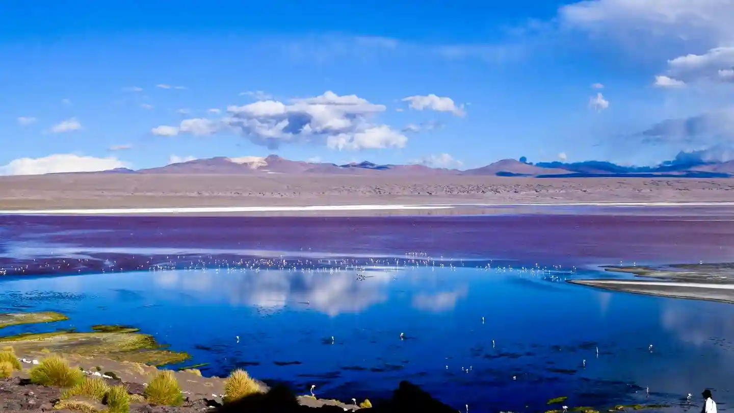
Table of Contents
- Quick Info Box
- The Reality of Arriving at Laguna Colorada
- Geological History and Cultural Significance
- Reality Check: What Instagram Hides
- Top Things to Do Around the Lake
- Photography, Lighting, and Drone Rules
- Exact Location & Navigation
- Weather, Climate & Seasonal Warnings
- Essential Visitor Facilities
- Estimated Budget Guide & Transport Costs
- What to Pack for the Altiplano
- Safety & Responsible Tourism
- Nearby Attractions for Your Itinerary
- Where to Eat & Stay Nearby
- Frequently Asked Questions (FAQs)
Quick Info Box
- Exact Location: Eduardo Avaroa Andean Fauna National Reserve, Sur Lípez Province, Potosí Department, Bolivia.
- Local Name: Laguna Colorada (Spanish for “Red Lake”).
- GPS Coordinates: 22°11′55″S 67°46′52″W.
- Altitude: 4,278 metres (14,035 feet) above sea level.
- Best Time to Visit: December to April (for flamingo breeding season) or June to August (for stark, cloudless photography, despite freezing temperatures).
- Entry Fees: 150 BOB (Bolivian Boliviano) for foreigners / 30 BOB for locals (This is the entrance fee for the entire Eduardo Avaroa National Reserve).
- Vibe/Highlight: A hostile, freezing, wind-battered wasteland featuring surreal red water and thousands of pink flamingos.
The Reality of Arriving at Laguna Colorada
When you finally pull up to Laguna Colorada, the first thing that hits you is not the view. It is the wind. It tears across the open plains of the Bolivian Altiplano, carrying a harsh mix of salt, sulphur, and freezing dust.
You will likely step out of your dusty 4×4 feeling utterly exhausted. The air up here at nearly 4,300 metres is violently thin. Simply walking from the car park to the viewing ridge feels like hauling bricks up a staircase.
But then you look down. The water is an aggressive, bruised shade of crimson, broken up by stark white islands of borax. Thousands of pink flamingos wade through the shallow, toxic-looking sludge. It feels entirely alien. It is a harsh, unforgiving environment, yet it remains the undisputed highlight of any multi-day Uyuni salt flats tour.
Geological History and Cultural Significance
The striking colour of Laguna Colorada is not a permanent fixture. It is the result of red sediments and the pigmentation of specific algae, primarily Dunaliella salina. These microorganisms thrive in hypersaline conditions and produce beta-carotene to protect themselves from the intense high-altitude UV radiation.
Long before European explorers or modern 4×4 tours mapped this region, the local Aymara people navigated these plains. In indigenous folklore, the altiplano lakes were often viewed with heavy superstition. Local legends sometimes attributed the red waters to the spilt blood of ancient deities or cursed demons who fought over the high peaks.
Historically, the surrounding region was largely ignored by the Spanish colonial mining operations that tore apart nearby Potosí. The lack of precious metals in the immediate lake bed, combined with the lethal winter conditions, left the lake mostly undisturbed. Today, official conservation efforts by the Bolivian National Service of Protected Areas (SERNAP) strictly control access to preserve the fragile breeding grounds.
Reality Check: What Instagram Hides
Social media portrays this lake as a serene, peaceful mirror of red water. The reality is drastically different. The wind chill factor here is notoriously brutal. Even if the sun is shining directly on you, the wind can drop the perceived temperature to well below freezing in minutes.
Altitude sickness, known locally as soroche, is a massive problem here. Many tourists arrive directly from sea level or lower altitudes without proper acclimatisation. Expect blinding headaches, nausea, and shortness of breath.
Furthermore, the infrastructure is incredibly basic. You will not find paved footpaths, warming stations, or luxury viewing decks. You will find dirt trails, squat toilets that cost a few coins to use, and an overwhelming smell of sulphur. If you are expecting a comfortable nature walk, you will be deeply disappointed.
Top Things to Do Around the Lake
Identifying the Three Flamingo Species
This lake is famously home to three distinct species of flamingo: the James’s, the Andean, and the Chilean. The James’s flamingo is the most prominent here, easily identified by its bright yellow bill with a black tip. You can spend hours simply standing on the ridge, watching them drag their hooked beaks through the mud to filter out the red algae.
Walking the Borax Peninsulas
There is a designated walking trail that skirts the edge of the lake. It takes you closer to the crusty, white borax islands that jut out into the red water. The crunch of the salt crust under your boots is oddly satisfying. Stay strictly on the marked paths; the mud surrounding the lake is deceptively deep and highly corrosive to footwear.
Wildlife Spotting Beyond the Water
While the flamingos steal the attention, the surrounding scrubland hosts other resilient altiplano wildlife. Keep an eye out for vicuñas (a wild relative of the llama) grazing on the sparse yellow grass. You might also spot Andean foxes slinking around the rocky outcrops, hoping to scavenge scraps left by tourist groups.
Watching the Water Change Colour
The intensity of the red water depends entirely on the sun and the wind. If you arrive early in the morning when the water is still, it often looks murky brown or dull grey. You need to wait for the midday wind to churn the water and agitate the algae. As the sun hits the agitated water, the crimson colour suddenly switches on like a lightbulb.
Photography, Lighting, and Drone Rules
If you want the classic, hyper-saturated red water shots, you must shoot between 11:00 AM and 2:00 PM. This is when the sun is directly overhead, and the wind is strong enough to stir the algae. Morning light is generally terrible for capturing the water’s colour, though it provides softer lighting for close-up shots of the flamingos in Bolivia.
Bring a polarising filter for your lens. The glare from the high-altitude sun reflecting off the white borax islands will easily blow out your highlights. A telephoto lens (at least 200mm) is absolutely non-negotiable if you want detailed shots of the birds, as you cannot walk close to them.
CRITICAL WARNING: Drones are strictly banned at Laguna Colorada. Flying a drone here violates the rules of the Eduardo Avaroa National Reserve. The noise disorients the flamingos, causing them to panic and abandon their nests. Park rangers actively patrol the area and will heavily fine you and confiscate your equipment on the spot.
Exact Location & Navigation
Laguna Colorada sits in the extreme southwest of Bolivia, rubbing against the Chilean border. You cannot take a public bus or a train here. There is no commercial airport nearby.
For foreign backpackers, the only viable way to reach the lake is by booking a multi-day 4×4 expedition starting from either Uyuni (Bolivia) or San Pedro de Atacama (Chile). The lake is typically visited on day two or day three of a standard three-day itinerary.
For local drivers attempting the route independently, you need a high-clearance 4×4, spare fuel, and satellite navigation. The “roads” are merely heavily corrugated dirt tracks carved into the desert. Sand traps and sharp volcanic rocks frequently destroy tyres. Do not attempt this drive in a standard sedan, and never drive it at night.
Weather, Climate & Seasonal Warnings
The climate here is classified as a cold desert. During the dry winter months (May to October), daytime temperatures hover around 5°C, but nighttime temperatures regularly plummet to -20°C. The wind during these months is relentless and cuts straight through denim and thin jackets.
The wet summer season (December to March) brings slightly warmer temperatures, reaching up to 12°C during the day. However, this is when the altiplano experiences sudden, violent thunderstorms. The dirt tracks can turn into impassable mud bogs overnight.
Lightning strikes on the exposed plateau are a genuine hazard during summer afternoons. If your guide tells you it is time to get back in the vehicle due to incoming dark clouds, listen to them immediately.
Essential Visitor Facilities
Do not expect comfort here. Facilities are incredibly rudimentary and designed purely for basic survival and passing traffic.
There is absolutely no mobile phone signal at the lake. Even local Bolivian SIM cards (like Entel or Tigo) will show zero bars. You are entirely off the grid until you return to larger towns.
Washrooms consist of heavily used, manually flushed squat toilets located near the main car park. You will need to pay 5 BOB to use them, and you must bring your own toilet paper and hand sanitiser. There is no running water for washing your hands. There are no restaurants or cafes on-site; all food and drinking water must be brought in your vehicle.
Estimated Budget Guide & Transport Costs
Visiting the lake is almost always bundled into a larger tour. However, you are responsible for specific out-of-pocket expenses while inside the reserve.
Prices fluctuate based on the Bolivian economy. Use this as a baseline estimate for 2026.
| Item/Service | Cost for Locals (BOB) | Cost for Foreigners (BOB) | Practical Notes |
| Eduardo Avaroa Reserve Entry | 30 BOB | 150 BOB | Mandatory cash payment at the park gate. Keep the ticket; it is checked multiple times. |
| Standard 3-Day 4×4 Tour (from Uyuni) | 900 – 1,200 BOB | 1,200 – 1,600 BOB | Includes basic food, transport, and driver/guide. Does not include park fees. |
| Public Toilet Access | 2 – 5 BOB | 5 BOB | Have small coins ready. Exact change is highly appreciated by the caretakers. |
| Bottled Water (Purchased at Refugios) | 10 BOB | 15 – 20 BOB | Buy water in Uyuni instead. Prices at altiplano shelters are massively inflated. |
| Hot Shower at Nearby Refugio | 10 BOB | 15 BOB | Only available at specific overnight stops. Often solar-powered and barely warm. |
(Note: Ensure you carry small denominations of physical BOB cash. Nobody out here accepts credit cards or digital payments.)
What to Pack for the Altiplano
You are packing for extreme wind, intense UV radiation, and cold, often all in the same afternoon.
- Thermal Baselayers: Merino wool is best. You need layers that trap heat but allow sweat to escape during short hikes.
- Heavy Windbreaker: A standard fleece will not stop the altiplano wind. You need a hard-shell, windproof outer layer.
- High-SPF Sunscreen & Lip Balm: The UV index at 4,300 metres will blister exposed skin in under an hour.
- Polarised Sunglasses: Essential to prevent snow-blindness from the white borax and glaring water.
- Altitude Medication: Consult a doctor before arriving, but carry Sorojchi Pills (available locally in Bolivian pharmacies) or Diamox.
- Coca Leaves or Sweets: Locals chew coca leaves to combat altitude sickness. It is highly effective and completely legal in Bolivia.
Safety & Responsible Tourism
- Do Not Chase the Birds: Never attempt to walk into the water or throw stones to make the flamingos fly for a photograph. It is deeply unethical and heavily fined.
- Hydrate Aggressively: At this altitude, you lose moisture through respiration much faster than at sea level. Drink at least 3-4 litres of water a day to stave off altitude sickness.
- Pace Yourself: Walk at half your normal speed. Running or sudden exertion can trigger a severe altitude headache within minutes.
- Take Your Rubbish: The wind easily blows plastic wrappers into the lake, where they are consumed by wildlife. Whatever you bring in your 4×4, take it back out.
Nearby Attractions for Your Itinerary
If you are travelling this far into the Eduardo Avaroa National Reserve, you must link Laguna Colorada with these nearby sites:
Sol de Mañana Geysers (Drive time: 45 minutes)
A violently active geothermal field located at 4,850 metres. You will walk among boiling mud pots and towering steam vents. It smells strongly of rotten eggs, but the alien landscape is phenomenal. Visit at sunrise when the cold air makes the steam clouds massive.
Termas de Polques Hot Springs (Drive time: 1.5 hours)
After freezing at the lake and the geysers, these natural thermal pools are a lifesaver. Sitting in 30°C water while looking out over the frozen salt flats is an unmatched experience.
Salvador Dalí Desert (Drive time: 2 hours)
A vast, barren valley littered with strangely shaped volcanic boulders. It looks exactly like the surrealist paintings of Salvador Dalí. It is a quick photo stop, but a visually striking one.
Where to Eat & Stay Nearby
You do not stay directly on the shores of the lake. All accommodation is clustered in nearby designated refuge zones.
Refugio Huayllajara:
This is the closest settlement, roughly a 15-minute drive from the lake. It is a collection of brutalist concrete and cinder-block dormitories. Expect six-bed dorms, no heating, heavy alpaca blankets, and electricity that shuts off at 9:00 PM. It is purely for survival, not comfort.
Hotel del Desierto (Ojo de Perdiz):
Located about two hours north of the lake. This is the “luxury” option in the region. It features private rooms, private bathrooms, and actual heating. If you are booking a private, higher-end tour, ensure they book you in here rather than the basic refugios.
Food is entirely handled by your tour cook. Meals usually consist of dense carbohydrates to help with the altitude: quinoa soup, llama steak, mashed potatoes, and pasta.
Frequently Asked Questions (FAQs)
Is Laguna Colorada always red?
No. The water requires direct sunlight and strong winds to agitate the algae and sediments. Early in the morning, it often looks brown or dull. It turns bright red by midday.
Can you swim in Laguna Colorada?
Absolutely not. The water is highly toxic, loaded with borax and specific harsh minerals, and cold. Wading into the water is strictly illegal to protect the flamingo breeding grounds.
Do I need a guide to visit the lake?
Technically, no, but practically yes. There is no public transport, and the unmarked dirt tracks destroy standard rental cars. Unless you are an expert off-road driver with satellite communication, taking an organised 4×4 tour is mandatory.
Will I definitely get altitude sickness here?
It is highly likely you will feel some symptoms, even if you are fit. Mild headaches and breathlessness are normal. Severe symptoms (vomiting, confusion) require immediate descent to a lower altitude.
Are there ATMs or places to change money near the lake?
No. The entire reserve operates strictly on a cash basis. You must draw all the Bolivianos you will need before leaving major towns like Uyuni or Tupiza.
Safe travels, and remember to respect the harsh limits of the high Andes.